Sunday, August 17, 2008

Beijing, China - 2008 Olympics

I’m really struggling to put together a post on our trip to the Olympics in Beijing. It would be easy and a little gratifying to lay into China for the pollution and lack of drinking water availability along with its oppressive government that electronically bugs taxi cabs and hotel rooms and censors the internet and broadcast media. But I guess that’s not really my job in this BLOG so I suppose I will stick to the Olympics and the site seeing we did.

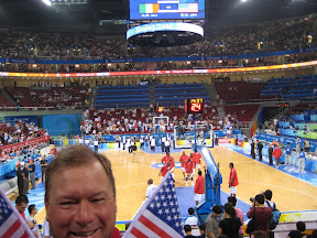
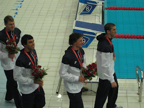
This trip was out of character for me since I am not a spectator sport sort of person. I don’t watch pro sports in the US much, and in all my (extended) time at LSU I only went to one football game. At Tulane, I didn’t go to any sports events. But the Olympics were really a treat. The athletes were amazing to watch, even in the early rounds when world class performances were just imperfect enough to show how amazingly difficult the feats really were. Watching things like women’s gymnastics on TV sometimes gives the impression that all of these teenage girls can do everything every time, but seeing the early rounds in person reveals that mistakes do happen and sometimes they are dramatic. Watching the Olympic swimmers doing their warm up and then effortlessly lifting themselves up and onto the pool deck in a single motion two feet above the water points out that not only can normal people not swim the same speeds as these guys, we can’t even get in and out of the pool the same way.

Watching the early rounds of volleyball left me with the idea that in earlier years I could have been down there playing, but as the elimination rounds progressed and the folks that probably should never have been there were defeated, the play improved and I quickly realized that I would have been one of the ones eliminated early.

The opening ceremonies were spectacular in the truest sense of the word. They were fantastic with perfect synchronization amongst hundreds of people at a time, and display after display of similar perfection. We were in the Bird’s Nest for six hours on opening night and didn’t see a single thing that could be called a mistake. Amazing. The fireworks set a new Guinness record with over 120,000 individual rounds fired over an 8 kilometer long path in the city. From inside the stadium we could see almost none of the fireworks, but we could see what you saw on TV from the jumbotrons inside and fireworks were still going off by the time we got out of the stadium at the end of the event. Just fabulous.

The Olympic venues were also spectacular. The Bird’s nest is something to see, but my favorite was the Water Cube. A building made principally of a visqueen like plastic in which the air that fills each “plastic pillow” is a structural element of the design. Amazing.

Because of the pollution, China will never make my list of favorite places to visit. How bad was the pollution? On our first day we could not quite make out the top of a cell phone tower in the city. On our tour of the Great Wall we could see only one or two battlements in any direction and we stood wishing that the day was clear so we could really take in this amazing structure.

But walking on the Great Wall was a singular experience. Our pictures aren’t great, but the experience was memorable. Strolling though the Forbidden City with its stark, vast squares designed to intimidate even the military was startling. The Forbidden City is mostly just a big empty space devoid of monuments or structure with any purpose but to intimidate and communicate absolute power. It is stark and lonely feeling in these days when it is merely a museum to days long gone. The same goes for Tienmen Square which is just huge and only slightly softened by the small gardens and special monuments that were erected for the Olympics. You never forget that the government in this country is all powerful and that “by the people, for the people” never entered anyone’s mind when it was founded or since.

China is without the exotic beauty that we found in other places in Asia we have visited. The monuments were to men gone but not forgotten and the architecture is purposed to intimidate. With almost no religion anywhere in the country, there are no temples, not even ones to false gods and that seems to leave only political reasons to build.

The people we came into contact with were typically Asian ie. smiling, pleasant and very accommodating to our needs at every point possible.

We learned after we got home that “bald and smelly” cab drivers had been taken off the road by the government.

We learned while we were there that violation of any of the “special laws” enacted for the Olympics are punishable by prison time and heavy fines. This includes unauthorized usage of the “Olympic Lanes” on the expressways and it was obvious that this law was strictly enforced because our bus had permission to use this lane and despite 3 or 4 other lanes being backed up for miles, we sailed down our lane completely alone on most occasions. Trips that we were told would take 1 – 1 ½ hours took us less than 15 minutes in some cases.

We learned after we left the country that many people were displace from their homes in order to clear the land needed for the Olympic venues. In the places where these people were relocated, signs were erected by the government saying “I participate, I contribute, I am happy.”

Well, I guess I couldn’t stick to the site seeing after all. God Bless America.

oVo

Saturday, July 19, 2008

Redwood National Forest


Brenda grabbed a much deserved day off Friday and we hustled North to the edge of California where we found the Redwoods National Forest. It was a long trip for an overnighter, but we've gotten pretty good at finding the good stuff when the opportunity arises. We made the most of this trip by taking a nice back-roads drive up through the perpetually congested Napa wine region, and then up through Geyserville before rejoining Hwy 101 at the Southernmost end of the Mendocino National Forest. The roads North of Calistoga on this route are excellent motorcycle roads, but there was alot of construction near where we joined up with 101. In CA they like to just shut down a lane and let cars through from one direction for a half hour and then the other direction. We hit it pretty bad this time and had a few long waits for our turn.

Having gotten off to a late start in the morning and being blocked by construction a few times, we arrived at our motel and turn around spot in Klamath, CA at about 7 PM and had some dinner. There was still light after we ate so we ambled over to a little trail near the hotel that said "Hidden Beach" but didn't give any indication of how far it might be. The trail was nice, but it was jungle. You know how dark it can be in the woods during the day and for us the sun was barely up when we entered the trail. Brenda led us briskly down the trail for about 15 minutes and we finally started hearing surf. A few minutes later and we were rewarded with the coolest beach I have ever seen. The beach was a half moon shape with huge rocks jutting out of the surf in random places. The beach sand was charcoal grey, almost black and as fine as flour, but more dense. The surf was "angry" and it just could not have been a more interesting place. I hated to pull us away after a 15 minute visit, but I knew the forest would be even darker by now. Sure enough....

We made it back to the world just fine after taking the right turn that we knew we had to take whether we could actually see the trail or not and somehow remembering the following right hand turn where the trail wanted to go straight. No big deal and definitely one of the things that made this trip and adventure.

In the morning we got up and rode the gondola to the top of the hill across the street from our hotel. It was foggy so we couldn't see much at the top, but the ride up was still interesting to see the sequoias, firs and spruce from this squirrels eye view.

We jumped back in the car and made our way to Fern Canyon where we walked down to the beach for more angry surf, then continued our route south homeward, but not before ignoring our GPS plea to keep us off an unpaved road that we figured would be a mile or two long. Forty miles later our jostled and juggled sports car looked like it had survived a Texas dust storm. Just another adventure. I must admit that when the GPS finally gave up and started plotting our position on a completely blank screen with no roads shown, and we had to decide if the spray paint arrow on the tree trunk saying "Hoopa ------>" could be trusted, I had had enough adventure for a bit.

When we emerged from the wilderness, we found ourselves blocked by a sports car club that had commandeered the road for the day to run speed trials up a 2.5 mile section of road. We had to wait for the heat to end before we could go back down the mountain with the race cars. They offered to let us run with the next heat since we were in the right kind of car, but I found out that the fastest time for the 2.5 mile course was 2 minutes and 13 seconds. This was on a mountain road, uphill with at least 6 hair pin switchback turns. In other words, they were averaging almost 70 mph from a standing start. I wasn't sure I could go that slow (HA!) Only one guy had lost his car off the road so far that day.

After more great mountain roads Southeast through Trinity National Forest we finally joined back up with the Interstate crowd to make tracks home. Great trip.

Click on any of the pics to see the rest of them at the web album

oVo

Thursday, June 26, 2008

Police Riding School

Back in May I lucked into the opportunity to participate in a 40 hour riding school put on by the Texas City Police Department. I have a friend that sells Harley Davidson Motorcycles and one of his customers invited him to come to a day of classes and my friend invited me. I was able to stay all week and complete the course. I am the only civilian that Texas City has ever certified as completing this course. 'Course I can't give tickets, but I sure learned a lot.

This is one post where I really suggest that you click on one of the pictures which will take you to the web album where the rest of the pics are stored. These pics are truly worth a thousand words and this class was worth a thousand bucks to me. Don't tell Texas City though, they may send me a bill.

I've been riding since I left home at 18 years of age. I have ridden all sorts of bikes. Dirt bikes, small street bikes, exotic Moto Guzzis, metric and HD. I've always paid attention on the street and I have takes some classes that teach riding skills. I thought I was a pretty good rider but this course really showed me that I didn't know much about handling my bike at slow speed in tight quarters. I think I learned a lot though, and developed confidence that I can put my bike where I want it to be.

The course consisted of six distinct cone layouts where the object was to avoid the cones. Speed did not matter, go as slow as you want or as fast as you can, just avoid the cones. We were all on 800+ lb Harley's except for one guy on a Honda Valkrye and two guys on BMWs. The Harleys all handled the course better than the other bikes because of the HD lower center of gravity and shorter wheel base. Each of the bikes can complete the course though, but with greater difficulty on the Honda due to the wheel base and the BMW due to the clutch set-up.

The first course was a slow weave in which cones were set about 18 feet apart and we just weaved back and forth between them. We were justifiably proud to complete that course with relative ease, but it turns out that the slow weave was just a tune up for the Offset Weave.

In the Offset, the cones are not in a straight line, but are offset by about 18 feet so that you have to make a hard turn at the first cone to line up on the next cone 18 feet away and requiring a 90 degree turn. Assuming you clear the second cone there is another one 18 feet away that may be a little tougher to clear depending on how you ride. Each mistake in position, speed or direction on these courses adds up on you because the layout of the course doesn't allow much room for corrections. If you are off by a foot on the first turn, you may be off by two feet on the second and so forth. A skilled rider can make up for small mistakes, but not for big ones, and we unskilled riders couldn't even make up for small mistakes at first.

It took us two full days to get everyone through the offset cones and onto the lane change course. The object on the lane change was to simulate the need to change lanes on a highway, but to do it in about 15 feet without knocking over any cones. Keep in mind that our bikes are about 6 feet long and we all had saddle bags that stick out and the bags were low enough to strike the cones.

After the offset and lane change we moved on to the 18 foot intersection. This course is best thought of as a big "Plus sign" with each end of the sign and each segment of the sign being 18 feet wide/long. We had to enter the intersection at one end and make a hard turn at each corner driving the bikes as far into each leg of the intersection as we could. Each turn in this course required a "wheel lock" turn in which the handlebars were forced as far as possible into the turn. The only way to straighten the bike at that point was with speed. Increase speed and you straighten up. Decrease speed and you fall down. A very interesting balancing act. It took most of us two days to master this course and some of us took even longer. It was only a five day course. Time got tight.

After the Intersection we only had a high speed "Maximum Effort Stop" and the Keyhole to go. The high speed stop was interesting because we performed it first using just back brake, and then with just the front brake. Finally we stopped using both brakes together. I am glad that I have two brakes.

The Keyhole was an 18 ft diameter circle of cones with a 4ft wide X 4ft long entrance/exit. We had to enter the keyhole, perform a full circle and exit out the same hole without touching a cone. OH... and did I mention that we had to do all these courses clockwise AND counterclockwise? Well, we did.

This course was a really great time for me. It was hard on my bike, but I gained alot of skill and confidence in putting my bike exactly where it needs to be every time and it showed me that no matter how good a rider I thought I was, there are always skills to be learned and more fun to be had in our sport.


oVo

Sunday, April 27, 2008

Ride For Kids

Once a year a bunch of motorcycle riders in the Houston area get together and take a little ride to raise money for medical research centering on brain tumors that occur in children. This event is called the "Ride for Kids" and it benefits the Pediatric Brain Tumor Foundation. (See links on right side bar)

We all pay about $35 to ride a 40 mile parade where the local police close whatever roads we are scheduled to ride (including interstates) and we putt down the road. But the work is done well before the day of the ride. All year, we have groups of bikers raising money for the effort and this year the Houston area riders raised over $280,000. These events happen all over the country and combined they add up to a tidy sum funding research that has had real results.

Years ago, it was common for a child with a tumor to pass away in the time between one fund raising ride and the next, but today we heard from a 31 year old nurse who was one of the early brain tumor survivors. The youngest patient we heard from today was 13 months old. She didn’t have much to say, but her father spoke for her and expressed the hope that he had for her future.

We bikers can't take credit for the advances that have occurred over the past 25 years that the Pediatric Brain Tumor Foundation has been funding research, but it is nice that a bunch of regular folks like us have found a way to be involved in furthering this effort.

My camera ran out of battery before much of the ride was complete today, but it was a good event for a worthy cause. Eighteen survivors and current patients from 13 months to 31 years old took the stage to tell us a little about their cases and thanks to the PBTF and Ride for Kids all of their futures look a little brighter.

Even the rain on the way home couldn't undo the good that came from today's ride.

oVo

Monday, April 21, 2008

Skaggs Spring Road


Skaggs Spring Road (SSR) was cited as "the best bike road in Northern California" by my riding buddy Joe. So without delay, Joe and I headed North today to check it out.

We rode 77 miles to get to Calistoga where the road turned good. Nice and scenic with some sweepers and a few tight twisties. But the main course was still to come and soon enough we turned West on the SSR. It was great. I took a bunch of pics with my left hand while negotiating the sweepers with my right hand on the throttle. I think it can give you an idea of how nice this road is and how much fun the sweepers are. Just after the big bridge I put the camera away because the road narrowed and wound its way through the forest with steep drop offs just over the edge of the pavement. It was no place to be careless so I wasn't.

SSR dumps you out on the PCH at Stewarts Point after a satisfying 45 miles or so of sweepers, hair pins, grand vistas and finally a jungle scene right out of Jurassic Park right before you see the Pacific Ocean. Great road.

The PCH was also a fine ride with views unparalleled. Click on any of the pics here to see the rest of them in the web album.


oVo

Thursday, April 17, 2008

Day hike through Pine Valley on Mt. Diablo

I had several items on my list of fun things to do this week. I was going on a motorcycle ride Monday but the weather turned even colder than normal with night time temps in the 30s and the days warming up slowly. To top it off, the guy I was hoping to ride with had a family emergency and wasn't able to join me so I just filed the map and will do it some other time.

I was also going to take the commuter train into San Francisco to scout for a weekend trip that Brenda and I were planning to take this Saturday. But, although the weather has warmed back up the forecast for the weekend looks cold and windy in the city so we are holding off on the Saturday trip too.

But the one thing that I had not planned to do, but that has been on my list for some time is to take a walk up in Mt Diablo State Park. Mt. Diablo is the biggest thing around here rising 3,849 ft and offering views of things as far away as the Golden Gate Bridge on clear days. One web site says that Mt Diablo provides views of more geographic area than any other peak except Mt Kilimanjaro. Not sure I believe that but there are some nice views. Check it yourself though at this site.

Anyway, last night I pulled out my trail map that I bought a few months back and with the help of the web found a trail route that I thought fit my needs for today. It was a six mile loop with a 1000 ft elevation gain and is rated "strenuous" or "moderate" depending on the website you find it on. For me, it took three hours and I rested about three times during the steepest portions of the climbing sections. Moderate is probably about right.

I picked up the trailhead at Macedo Ranch which has a ranger station at it along with some picnic tables, drinking water and water for horses. The state charges $3 on the honor system to park in their gravel lot so after stuffing an envelope I strapped on my day pack and headed out.

I was a little disappointed initially since the "trail" was actually a dirt road that they use for fire abatement during the dry season. It turns out that most of the trails here are like that. But at the furthest point in my walk today I took a hard right hand turn onto "Secret Trail" and was rewarded with a foot path that gained elevation from 1175 to 1465 ft in about a mile and joins BBQ Terrace Rd with Wall Point Rd.

My walk today provided plenty of rewards besides the clean air and exercise. I saw lots of scenery and plants that I am not used to seeing. I listened to wild turkeys from just over the next ridge and was stopped in my tracks by bees buzzing so loudly that they commanded attention. I even heard that "Eagle screech" sound that all the TV shows use when they want you to know that you are viewing a wilderness program.

Mt. Diablo is far from wilderness and does not even allow back country camping. Normally there is no where to camp in the back country because of the scarcity of water, but today I made three stream crossings and enjoyed touching the icy snow runoff each time.

My route today started at Macedo Ranch and proceeded North by Northeast about 0.87 miles along Wall Point Rd to Dusty Rd, which branches due North (left.) Dusty Rd descends 260 ft in a half mile and intersects with Stage Rd before merging into BBQ Terrace Rd in another 0.45 miles and after ascending a mere 80 ft before splitting from Stage Rd for good. At this point you are at 715 ft with a steady climb to 1175 facing you over the next mile to the intersection of Secret Path. Turning Right (SE) on Secret Path continues the climb over the next mile to 1465 ft where you rejoin Wall Point Rd and climb the remaining 135 ft in just a quarter mile or so before starting your descent with the sheer drop to your left. Look closely and you may spot some interesting erosion patterns in some of the rocks jutting up from the canyon floor 500 feet below. The descent is easy as long as your knees are good. I stopped a few times to rub my worn out hinges. I guess my basketball injury from earlier in the year is not quite healed yet. One and three quarter miles later you intersect Dusty Rd again, only this time you turn hard left (SW) to get back to the trailhead having seen wonderful vistas and no telling what else.

With 20,000 acres and over 100 miles of trails I suspect that Mt Diablo has not seen the last of me... …or me of it.

oVo

Saturday, April 12, 2008

Point Arena Light House

Our mission for today was to get North as fast as we could and then cut over to the Pacific Coast Highway and head South for a nice drive home along the wonderfully scenic PCH. Like all of our California trips so far we were surprised by the scenery, both on the PCH and while getting to it.

We drove Northward diving deep underground through the tunnels through the mountains on HWY 24 and then across the San Francisco Bay on I-580. I was completely surprised to see San Quentin located right on the bay. Man this is some high dollar real estate put to use as a retirement home for criminals. What a view they have. Well, they WOULD have a great view I guess.

We stayed inland and fought the weekend traffic through Novato, Petaluma and Santa Rosa Continuing to stretch our legs ever Northward. Finally after we cleared Santa Rosa, HWY 101 narrowed to four lanes and the traffic thinned out making the driving a little more enjoyable and less like a massive session of "Dodge Car." HWY 101 is scenic enough but I was eager to get off of it and onto some smaller and more interesting roads.

We finally did that at Cloverdale where we veered West by Northwest on Hwy 128. Now that is a great road; two lanes of smooth pavement winding its way toward Booneville where we stopped for an "organic hand made" lunch. Booneville looks to us like sort of a hippy holdover, full of interesting looking people and more cafes and restaurants per capita than anywhere I can recall. Nice town and it is in a good spot in the road for a day trip. Just far enough away to have us wanting a little break.

After lunch we hung a hard left on Mountain View Road where we enjoyed the 30 mile meander over the last mountain range before we hit the coast. Mountain View Road is a beautiful run through a redwood forest and allows speeds less than 30 mph with no penalty. Go faster than that and you are either a really good driver or about to meet a new group of doctors. While still about 8 miles from the coast we broke out of the forest and saw the Pacific Ocean in the distance. Cool.

We stopped at the lighthouse and snapped a few pics. I have learned that I have to budget my time at these ocean overlooks because I could really just sit and watch the swells all day. After the photo session we headed South on the PCH and alternately caught spectacular views of the ocean and ducked into the forest as this famous road shared it's multiple personalities with us. At one minute you are at sea level and could walk down to a secluded beach not even seen from the road, and the next moment you are 1000 feet above the surf on a road carved out of the cliff. Top a hill in the forest and ease down into the next glade and the temperature can drop 10 degrees. Now we know what a micro-climate really feels like.

We were in the convertible today but this ride would have been a great bike trip. It was a long day at 330 miles and much of that in the 30 - 35 mph range. Any serious exploring along the PCH North of San Francisco is going to require a multi-day trip but I am absolutely certain that it will be worth it.

Remember, you can click on any of the pics in this post and go directly to my web albums where you can see full size versions and a few that I didn't have room for here.

oVo

Monday, April 07, 2008

Day Ride Toward Reno

I have a lot to learn about planning rides in California. After about an hour of interstate and some two lane highway, which was a small price to pay for getting to the roads I suspected I would find on the way across the Sierra Nevadas, I spotted snow in the approaching mountain peaks. I pressed on figuring that even if I had to turn around, it would still be a good day of riding.

It ended up taking me about 2 hours to clear the interstate and the flatland traffic at Jackson, CA. By this time I had already enjoyed what is becoming a staple of my forays into this scenic state. I had run past the windmills along I-580 in Livermore and had taken in a new set of rolling grass covered hills as the bike and I steadily climbed toward the snow.

In Jackson the changes became more abrupt and the road started winding its way upward via the path of least resistance. Kit Carson first navigated this pass that became a crucial link across the Sierras for the Pony Express. I encountered my first roadside snow at 4500 feet and thought to myself "This won't be so bad." That was before I realized that the road kept climbing to 8000 feet.

I had dressed for temperatures between 50 - 70 degrees F because I left the house at about 10 AM after the chill was out of the air. Normally things warm up around here by about 2 and by 5PM it is in the high 60s or maybe low 70s. Well, in the valleys at least. Up in the passes things are a little different.

When I stopped for lunch, I put on my heavy gloves. The temperature was in the low 50s. At 5000 feet, I checked the temp again and it was in the low 40's. At 6700 feet I had had enough and stopped to put on my jacket and pant liners which are good to the low 30's. Good thing too because when I checked before I re-mounted the bike, it was 36 and it stayed that way for quite some time.

I continued climbing past the signs that declared the area an avalanche hazard and past the swing gates that are permanently installed for the inevitable times when the road must be closed. Dodging just a few ice boulders in the road (rocks really) I eased my way to the top and then down the other side of the pass into the Diamond Valley.

My route called for a right turn on CA 89 which I took, but as I made the turn I saw what I had expected to see ever since first spotting the snow on the distant peaks. The passes back to the other side of the mountain range were closed along HWY 4. I figured I was lucky to get this far and continued down the road a little while until I found a beautiful little trout stream where I shot a few pics before heading back the way I came.

This turned out to be a great ride because it had 170 miles of smoothly paved roads filled with gentle sweepers and a few hair pins along for good measure. On the way over the pass the first time, I rode between 50 - 60 mph taking in the tall pines, snow fields and beautiful vistas. On the way back I picked up the pace a little and really enjoyed the bikes capabilities on these winding roads.

oVo

Friday, April 04, 2008

Vote Gridlock

Remember when we thought a 50% effective tax rate in some northern European countries seemed outrageous. Well here ya go.

If you file individually and earned just $31,850 in 2007 your federal tax rate was 25%. Your Social Security tax was 6.2% and Medicare added 1.45%. If you live in all but 9 states, you also incur a state tax liability that varies between 3% - 9.3%.

So far we are paying between 28% - 34.3%

We also pay sales tax on pretty much everything we buy. That's generally about 8.25% And if you earn around $32,000 per year, I am pretty sure you are spending every bit of it to keep the wolves from the door so it too is effectively an income tax. That means that right here in the good old USA we are paying 40% tax. We won't even discuss the 50 cent per gallon fuel tax (for now.)

So what do you do about this situation? Well, first I suggest that you fire anyone that you ever voted for in any local, state or federal election. They are all complicit in this grab for YOUR cash. Some tax is necessary, but is it really necessary to take almost half of the salary of a school teacher, bus driver, and secretary? Where is all this money going?

"Vote Gridlock" is what I say. When too many Democrats are in office, they enact whatever spending plan they want and it all comes out of your pocket. Ahhhh, but when the Republicans are in power, guess what... they do the exact same thing. The only way to stop them is to try to make sure no one has the advantage and we can only do this by keeping the Congress as close to 50/50 as possible and hoping that a few from each party will cross over when the really worthwhile ideas emerge from the noise.

There is one other thing you can do if you are self employed or retired. Be careful about what you earn. Stay on the right side of the delineations in the federal tax schedules. In 2008 those delineations will be as follows;

Taxable income -> Fed Tax Rate
$0 - $ 8,025 -> 10%
$8,026 - $32,550 -> 15%
$32,551 - $78,850 -> 25%
$78,851 - $164,550 -> 28%
$164,551 - $357,700 -> 33%
$357,701 - $lots more -> 35%

Staying below one of these lines in the sand can save you thousands. Good luck

oVo

Tuesday, April 01, 2008

WOW - What great roads

From San Ramon to the Lick Observatory atop Mount Hamilton, CA is about 180 miles round trip. The thing that is amazing to me as a flatlander is that after about 28 miles of the route we took today, there is a sign that says "Mt Hamilton 44 miles." The thing about this sign is that the 44 miles is nothing but twisty turny scenic road that is pretty much perfect for motorcycles. And you gotta know that a 44 mile trip up to the observatory on twisty roads involves a 44 mile return trip down the mountain on those same roads. That's roughly half of a day ride that is nothing but twisties. Wonderful.

I really don't know why I say "pretty much perfect" to describe these roads. I can't think of much that would improve them. The surface is good, the scenery is fantastic and our average speed was 34 mph (according to the GPS - not according to me - who had time to look at the speedo?) I swear there was one right hand turn with no shoulder... I had taken it in pretty good fashion with the bikes tire near the right hand edge of the road at the apex of the turn. I swear that I believed that although my tires were on the pavement, my shoulder was hanging off the road over a 200 ft drop off. I'm sure it wasn't... it couldn't have been right??? RIGHT??? At any rate, the penalty for not paying attention to the road on this ride would have been steep. Literally - STEEP. And the temptation to let your eye wander is strong. Such a beautiful place.

I'll go back to Mt Hamilton again because when I got home and looked at the map, it turns out that I missed more than half the good roads that climb that hill. Gotta go do the rest of the attraction and soon.

oVo

Saturday, March 29, 2008

Light bulbs


I'm a little cranky.

I have a friend who calls himself "Grumpy" and who has a little Elf doll that looks like "Grumpy" in Sleeping Beauty strapped to the back of his motorcycle to prove it. But the fact is that I am much more deserving of the title than he is. Here is an example....

A few years back.. say three years, I bought some of these high dollar fluorescent light bulbs to replace some standard incandescent light bulbs in my house. Now I didn't just buy a few, I bought about 20 of 'em. And you gotta know that these bulbs are not cheap. You can get a 4 pack of standard Soft-white incandescent bulbs for about $2 and these fluorescent things cost me around $10 each. So here it is, a couple of years later and some of these high dollar bulbs have burned out. Now keep in mind that I have been in Bangkok for a full 12 months of this time so don't be thinking that I should be happy with three years out of a bulb. I have had regular bulbs last for YEARS and they don't cost $10.

So I start looking around for info on the true cost of light bulbs.... and you, because you chose to read my BLOG have to put up with this resulting rant.

Here's the deal.

Assumptions
Standard Incandescent 60 Watt bulb - cost $1.50 for a pack of 4
LONG SUPER LONG LIFE fluorescent GE 60 watt equivalent - cost $14 (that's right - $14 per light bulb - see why I am grumpy!!!)

Now, A standard bulb is supposed to last about 1000 hours. You can verify that from any number of sources with a simple web search. One of these super duper long life fluorescent bulbs is supposed to last 10 times longer... HA!!!!! In your dreams. Maybe some of them do, but not the ones I got... so I went to figuring how much I overpaid for my crappy fluorescent bulbs. Here is the result.

Paying $1.50 for 4 standard bulbs means I pay about 37 cents per bulb. That bulb is supposed to last 1000 hours, but alot of mine seem to last longer... maybe 2000 hours right.... am I right???? You know I am! And I am supposed to be happy spending $14 for a stupid fluorescent bulb... I don't think so.

Anyway, the $14 "long life" bulb is supposed to last 10,000 hours. HA! Even if it does last ten times longer, I am paying $1.40 for the same amount of time that the cheap bulb is supposed to last. Man am I getting grumpy.

So this standard bulb is a 60 watt bulb. I pay about 15 cents per Kilowatt hour for electricity, so to operate my bulb for 1 hour costs me about 1 cent. A little less. But that high dollar bulb only uses 15 watts, so it costs alot less. But so what. A lot less than a cent still ain't much. Actually it is about 0.2 cents. Too little to count.

Lemme figure this out a second. A standard bulb costs $0.37 plus $0.01 per hour to run and it lasts 1000 hours. That's a total of $10.37 over the life of that bulb. Wait a second. The whole bulb and the energy it takes to run it is cheaper than just the bulb when you buy that expensive one! MAN am I getting grumpy!

OK, just for the exercise, I'll look at the fluorescent bulb. It cost $14 (crap!) and it uses 15 watts per hour so that costs hmmmmm.. 0.2 cents per hour. OK, that's pretty cheap to run. The standard bulb cost 1 penny - 5 times as much. But still, we are talking pennies here.

OK this fancy bulb is supposed to last 10,000 hours. HA!!!! so over the "supposed" life of the fancy bulb it would cost me $22.50 in electricity costs PLUS the $14 that the original bulb cost, that's a total of $36.50. That's TOO MUCH to run a light bulb.

Hmmmmm, what would the standard bulb cost I wonder. Let's see. 37 cents per bulb and the bulb lasts 1000 hours. That's $3.70 for enough bulbs to last 10,000 hours. And each bulb takes 60 watts per hour at 14 cents per KWH so that's $90 in electricity... WAIT JUST A SECOND HERE!!!! $90 to run a light bulb.. That's TOO MUCH! Lemme check that again

60 watts X 10,000 hours = 600,000 watt hours = 600 KWH
$0.15 per KWH X 600 KWH = $90.... hmmmmmm

Ok, lemme think. The high dollar bulb cost $14+$22.50 for electricity. That's $37. And the cheap bulb cost 37 cents plus 1 cent per hour, but for 10,000 hours that adds up to $90. CRAP!!!!!

Yea, but wait a second. The thing that ticked me off was that some of the bulbs I bought didn't last very long. I don't know how long, but it didn't seem very long. So what if the fancy bulb only lasts half as long as it says it will? Yea, what if it only lasts 5000 hours and then I have all that money tied up in an expensive bulb that crapped out. Let's see.... $14 for the bulb, and 0.2 cents per hour for 5000 hours is $14+$10 so that's $24. The same deal for the regular bulbs would be 5 bulbs (1000 hours per bulb) at 37 cents per bulb... that's a buck 85, plus 1 cent per hour to run them that's 5000 cents or ... .wait a second.... 5000 cents is $50! So even if the fancy bulb only lasts half as long as it is supposed to, it is still twice as cheap overall as the cheap bulb. Hmmmm

Hey, but what happens if my cheap bulbs last twice as long as they say they should? OK, at 37 cents per bulb, and it lasts twice as long.... Oh crap so I save 37 cents.. so what, I am spending $50 to keep the stupid thing running.

I think I am less grumpy than I was a little while ago.

Here is the chart. The green line is the cost of the "fancy bulb" as it lasts longer and longer. It dips below 1 cent per hour at a life of 2000 hours. At 10,000 hours, it costs 1/3 as much. There is a similar red line that shows that the cost of the "cheap" bulb is basically 1 cent per hour, no matter how long it lasts. This chart stops at a bulb life of 3000 hours. Imagine how it would look at 10,000 hours.


oVo

Nice day trip to Carmel and Point Lobos State Park

Today we took a little drive down South, mostly to take in some of this new scenery, but we ended up at a place called Point Lobos. If they haven't filmed movies at this location, I don't know why. It is beautiful.

We headed South in the most efficient manner possible until we got about 90 miles from home. We then ventured off the beaten path to some twisty roads that included Laureles Grade Drive, a nice little stretch with 10% grades, up and down the pass. We even got further off the trail when we took a side trip off the pass onto a 1 lane road that my GPS said would be even more interesting but ended up dead ending. Oh well, it was still interesting.

After the pass, we pretty much just found the Pacific Coast Highway (PCH) and headed about 5 miles south to Point Lobos. It takes $9 to get into the park but I could have spent a week there just watching the waves. It was a little cold and very windy so we didn't stay long, but take a look at my pics to see some of the amazing scenery.

When we left Point Lobos, I had noticed a road called 17 Mile Drive that looked interesting. Well, it is so interesting that the residents have decided that they can charge a $10 toll just for driving through. It's pretty worth it though, at least if you are just visiting. We paid the man and drove along the shaded road with the Pacific Ocean on our Left and amazing houses and golf courses like Pebble Beach, Cypress Point and Spyglass Hill along with some less notables as well. It was a great drive. Brenda thinks that this is where Clint Eastwood probably lives but we didn't see him jogging so we don't know.

After the 17 Mile Drive, we just returned to the PCH and headed homeward. We got pretty far along and heard that our planned route was suffering from a Semi accident earlier that day on the bridge that we planned to use to cross the San Francisco Bay. We backtracked about 10 miles and took a more direct route home having had a great drive.

If you look closely at the map you will see a little box about midway down on the right that says "Lick Observatory" on Mount Hamilton. That's where I am headed Tuesday.

oVo

Thursday, March 27, 2008

A little Catch-up


Ever since coming home from Thailand in October last year, I have let this Blog sit idle. There are a few reasons for that I guess, but none of them are because we have quit doing fun stuff. Let's see... I went diving in Honduras in October 2007, and took a great trip to Big Bend National Park shortly thereafter. We got a little tied up trying to find a place to live in San Ramon, CA while maintaining our place in Texas, but even that was adventurous in the "something different" sense of things. One reason I like blogging is because from time to time, I review the posts here and recapture some of the fun I had on these trips. And that's why I am going to pick this blog up again and keep it pretty current.

Since we now have a foothold in the far west of the US, we are using it to great advantage. Last weekend was functionally our first in CA. We have been here a few other weekends, but those days were consumed with apartment hunting or moving chores. But this past weekend we ran off from our remote base here and hit the trail to Yosemite National Park. What an amazing place. Even the drive there and back is amazing. We went out on Hwy 120 and came back on Hwy 140. Hwy 140 follows the Merced River all the way down the mountain so it is just spectacular.

Yosemite itself is pretty crowded, we thought we were rushing the season a bit since there is still snow in the higher elevations, but even this early the accessible parts of the park are packed. But we were able to basically drive up to Yosemite Falls and then take a couple of short hikes to Mirror Lake and Columbia Rock. Not back country hiking by any means. The trail to Mirror Lake is paved (for crying out loud) but the trail to Columbia Rock is far more severe.

Columbia Rock is only 1 mile from Yosemite Lodge where we stayed, but it is also 1000 ft higher in elevation. That is a average grade of 34% and that can wear on your legs. Still it was a great walk and left me wanting more. I came home and started looking for a good back country hike for when the snow melts.

We have other trips planned and we are looking forward to seeing this different part of our country. I'll keep you posted.

oVo