Monday, July 17, 2006

Alvin to Galveston with Dinner in Freeport

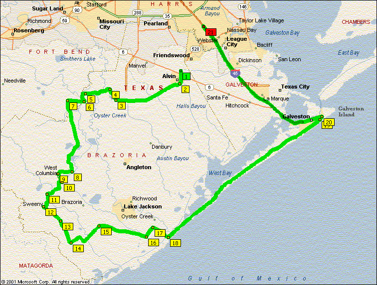
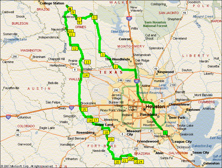
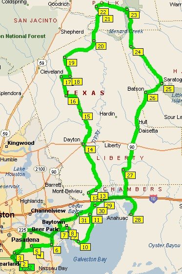
Here's a nice gentle ride for enjoyment of the wife. Starting in Alvin, TX and winding a leisurely rumble through the evening cool. Ok, it's July in South Texas, but I gotta dream of cool weather sometimes.


Anyway, here's how Santa Chuck set-up and reports the 165 mile ride.


We left the Shell station in Alvin (528/35) @ 4:15pm. Seems many had not been on some of these roads and CR316 out of 4 corners was a first for me also. I heard some good comments about the roads and selection so guess we did good. The resturant is called On the River, 919 West 2nd Street, Freeport. The "river" is old lost river and this resturant used to sit on the other side of 2nd street years and years ago. Capt Elliotts fishing fleet operate across the street from current location of the resturant. Turns out that I was the only one to have ever eaten here before. Bet it won't be the last time for this group! Our waitress was Audrey and man was she good. She ever took all of Todds BS and came back for more. The corn bread you'll just have to try and the home made cole slaw, too good to be true. Really TALL glasses of ice tea and water to quince our parched bodies and tasty food was consumed. We decided to take the Blue Water Hwy down to Galveston and then asked Todd to lead us to "The Spot" on the Seawall. There we took part in some creamy ice cream for dessert. More visit time then Todd took us via the Strand to Harborside to 45 and home.

Turn-by-Turn

SR-35 S to 1462 turn Right

1462 to 521 t
urn Right
521 to CR42 turn Left (my favorite local road)

42 back to
1462 turn Right
1
462 to Cow Creek Road turn Left
Cow Creek
Rd changes names to Nash Rd and CR 25 CR25 to Columbia Lakes and turn Right on 35
35 to 36 turn Left

36 to 522 turn Right

522 to 1459 turn Left

1459 to 524 turn Left

524 to CR316 go straight
316 to 2611 turn Left

2611 to 36 turn Right
36 turns into 288 and then 2nd Street
Look for the resturant and enjoy


After Dinner, mount up and head out and turn Right on Ve
lasco Blvd Velasco to 322 turn Right 322 to the Blue Water Highway turn Left

Have $2.00 ready for the toll bridge over to Galveston and just follow the highway al
l the way in.

"The Spot" will be on your Left, at about 25th street.
After your ice cream, you can head back toward where you
came and take any Right hand turn or continue down the sea wall and take any left to get to SR 87 which turn into IH 45 to take you back to Houston. Have a great trip.

oVo


Monday, July 10, 2006

Hill Country Weekend July 2006

One of the things I like best about my riding group is its informality. We have no officers, no dues, no meetings except to ride (and/or eat) and we don't restrict ourselves to a specific type, brand or configuration of ride - or of rider for that matter. We have riders that like to ride fast and enjoy the turns. Others live for the scenery and take things slowly. We have V-twins, opposed sixes, Silver Wing scooters, antiques and shiney new rides. About the only thing we don't have are crotch rockets, but that's not by our choice. We just can't keep up with 'em.

Anyway, all that is to say that our Hill Country Ride this year reflected our group's diversity. We arrived at our base camp (D'rose Inn) from Thursday afternoon through Saturday night and while we were there, we set out in small groups on a total of three separate group rides, two tubing trips, a hiking trip and a bat flight outing. And all this not including the rides to and from Leakey. Quite a trip for a thee day weekend. If you went on this ride and didn't enjoy yourself, I just can't figure out who you could possibly blame. There was something for everyone.

A note about D'Rose Inn and its Inn Keeper Deb Rose. All the rooms and cabins at the Inn are clean and well appointed. No sagging beds or clinking pipes in this place. Most, if not all rooms have a microwave and fridge. There is no TV, no phone, no internet in the rooms. Not a bad thing if you ask me. Each room is cooled by a window style AC unit that provides cool air along with white noise to help drown out any traffic from the highway or loud pipes arriving after bed time. I actually like that sort of background noise and I slept like a log.

Deb is re-modeling the rooms and cabins and is about half done. My room had a stone wall, wood ceiling and fresh new paint. All of the rooms and cabins have been recently painted, but not all have the decorating touches that mine had - but they will. Deb is "living her dream" (her words not mine) and is passionate about the comfort of her guests. One note for our friends of great stature. The shower in my room was 3 ft square. If you are 4 ft square, be sure to tell Deb that you'll want a room with a regular size tub and shower.

D'Rose Inn is rated #1 in Ride Texas Magazine and it is well earned. We wish Deb continued success.


The ride over was about 350 miles avoiding all interstates. Lunch was great at the Salt Lick BBQ resturant in Driftwood, TX. We also enjoyed a brief stop at Canyon Lake to watch the water skiers and browsing deer.


The ride back home Sunday was about the same distance but a different route.

Friday, our early arrivers were led by Santa Chuck on a loop West of Leakey for sight seeing and a laid back day in the hills.

Saturday, two group rides focused on the thee sisters. The first group sought a ride that focused on scenery and vistas while the second group went for fast curves. Both groups got what they wanted, and amazingly from some of the same roads.

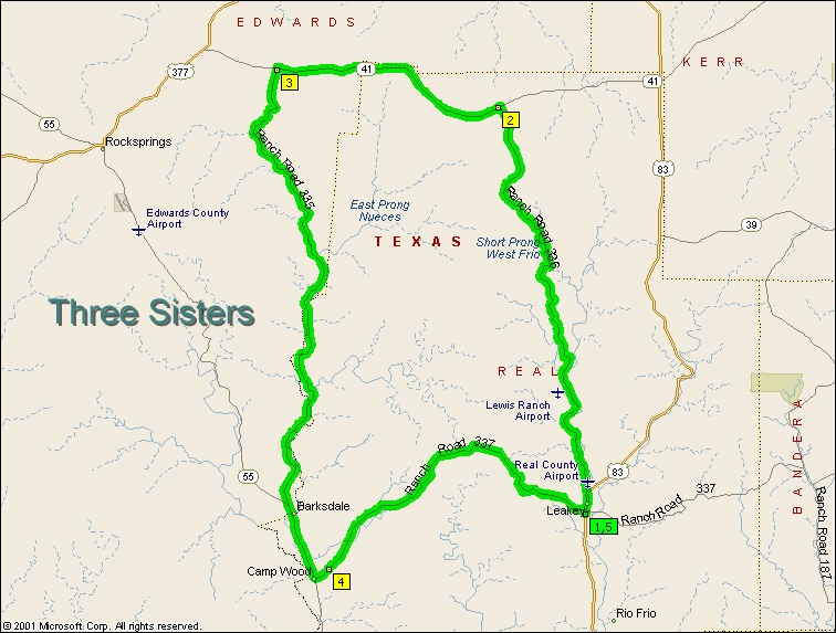
The three sisters is a great loop. Maybe the best in Texas that I have ridden. I'd like to provide my impression of these three siblings if I may.

These Texas girls have much in common, starting with their names, RR-335, 336, and 337. They also share the curves and roller coaster changes in elevation that keep us coming back for more. But there are important differences too.

For me, Sister 335 on the West side of the loop is the girl I could live with forever. She moves North to South with dramatic curves and thrilling hills that float your stomach at the top and give noticable G-forces at the bottoms. With a hint of wild country in her vistas, and just a bit of danger from the deer that may cross your path at any time of day, she could keep me interested for a lifetime.

Sister 336 on the Eastern edge is a bit of a prude. She shares the same topography as her more desirable sister to the West, but she teases you with a short set of curves and hills, but then makes you pull up short with annoying cattle gaps that may or may not be a smooth crossing. I just couldn't maintain a relationship with such a tease.

Sister 337 is the mature girl. So mature in fact, that she is currently undergoing a bit of a tummy tuck for a ten mile section West of Leakey. Don't let it concern you, the road is dusty but not "loose." Just slow down and let her take you over to the next section of good pavement. While not part of the Three Sisters Loop, Sister 337 shows you that she has just as much to offer as her North/South siblings if you ride her East of Leakey. She has great hills and turns, and none of those annoying cattle gaps.

Now for the side trips.

Garner State Park has lots to offer, from hiking, and swimming, to music and dances in the evening. Some of our group enjoyed all of these features.

There are tubing opportunities seemingly at every nook of the Frio river. The water was down a bit this trip, but Deb, pointed us to Happy Hollow which shuttles tubers to a stretch that still had enough water to keep us moving and cool in the hottest part of the day. In wetter seasons, the Frio promises a faster trip and many more options for places to start and end the day.


The Bat Cave near Utopia is home to the second largest population of bats in the US, and the largest that is open to the public. Well worth the $10 price to get in, the bats started flying at about 8:30, and were still leaving the cave at 9:00. An estimated 3 million flew past us, some at eye level when you could hear their wings push by. The proprietor said that the bats live over a mile inside the cave, and the guano is more than 6 feet deep for that entire mile. Take a look at some of my pics.

RESTURANTS - Live to Ride, Ride to Eat

Vinnies Italian
on the West Side of 83 in Leakey - Rated highly by Ride Texas Magazine. I had Pizza which had great flavor. A small one was twice as much as I could eat for $13 including tax and tip. The crust is the kind that is chewy rather than crispy. Lots of people love it.

Mama Choles Mexican - Just down the road from the Frio Canyon Motorcycle Stop in Leakey - Superb Tacos. Best I've ever had.

Hill Country BBQ - Also on HWY 83 (most everything in Leakey is) I didn't eat here, but it is recommended by several folks in Leakey.

Some other place - That Frio Canyon MC stops said has GREAT fried chicken - but it is only open sometimes. Ask Deb for details.

Well, enough talk. Let's go riding


oVo

Saturday, June 24, 2006

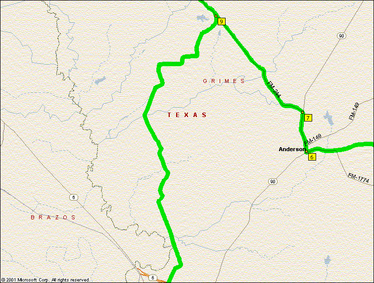
Ride To Carlos - 6/25/2006


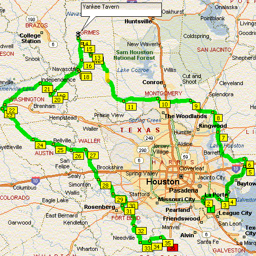
If you are going on the ride to Carlos with Chuck this Sunday, here is a preview.

Turn-by-turn
Leave Dixie Diner on 45N toward Spring
Left on 2920 to Tomball
Right on 249 to Pinehurst
Left on 1774 to !468
Right on 1468 to Dobbin
Continue on 1468 to 2819
Left on 2819 to Anderson
Right on 90 to 244
Lefto on 244 to Carlos
LUNCH at Yankee Tavern
Leave Carlos going South on 244
244 to 3090
Right on 3090 - This is the "Fourth Sister" ---->
Left on 6 through Navasota
Left on 2 to 363
Right on 363 to 1488
Right on 1488 back to 362
Left on 362 to Brookshire
Left on 90 to 359
Right on 359 to Fulshear
Left on 1093 to 359
Right on 359 to 90
Right on 90 to Richmond
Left on 762 to 1462
Left on 1462 to CR 42 (wooo hoooo)
Left on 42 to 521
Right on 521 back to 1462
Left on 1462 to Alvin

Y'all have a ball

oVo

Wednesday, May 10, 2006

Chucks Colorado Trip - Saturday through Wednesday - UPDATE


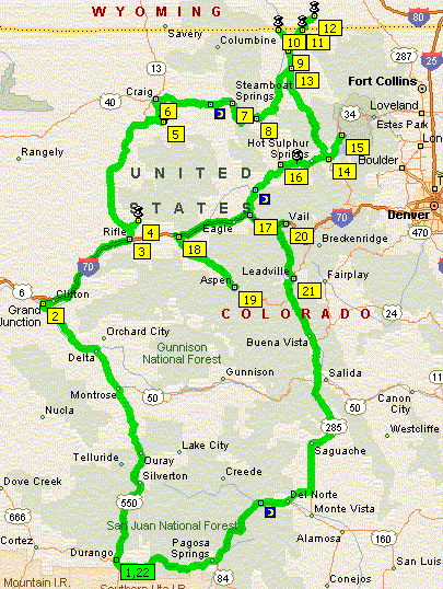
Update - Chuck forgot to tell us about a short side trip he made into Rocky Mountain National Park. The update is in Blue below and the map has been updated to include this 50 miles or so venture.

Don't forget that you can click on any image to get a larger version and see these maps better.

Try to feel sorry for Chuck when he feels forced into taking the quickest and most direct route back to Durango and it ends up being US-24, one of National Geographic's most scenic roads in the US.

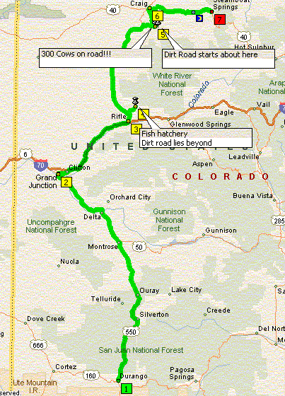
He is having a great time, losing some luggage not withstanding. Take a look at the overall map so far, and the breakout maps below. I've tried to edit some of his comments to give you a feel, but for the full version, you should really consider joining MLC on our annual ride to Arkansas coming up. Chuck will be in full display mode to tell us all about the Rockies while we ramble around the Ozarks.

Saturday
From Durango, take 550 to Silverton. Nice views since the mountains had gotten more snow last night. Two passes and one 10mph twist tie (this is better than a twistie) just before you head toward Ouray.

In my book, the road between Silverton and Ouray is one of the best in the state. Not that far (20 miles) but you better be on your toes because there are many cites called "falling rock" you must pass through.

If you want to
scrape your floor boards, this is the road. BUT, make a mistake and you are some 300/600+ feet down into the canyon. Beautiful is not the right word for this 20 miles!

Out of Ouray, stay on 550 thru Montrose to Delta and then take 50 into Grand Junction.


Sunday
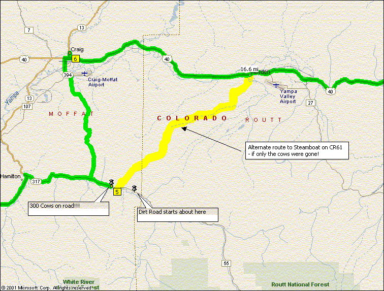
The sun peaks into the valleys about 5:30am up here. By 6am I had loaded the bike and turned the ignition key. Out of Grand junction, I took I70E to Rifle and 13N to CR325. Turned right on 325 and road the twistie ties for about 12 miles to a fish hatchery. Just past this place, the road turned to dirt. So, nice canyon ride but retraced my steps to 13 and turned North again. At CR317 I turned right. Both these county roads show paved and they were (for awhile).

Anyway, abo
ut 8 miles up 317 and find a man on a 4 wheeler
(at a curve) franticly waving his arm for me to stop. So I pulled off just about the time I could see around the curve. There was 200 - 300 head of cattle walking right downt the road toward us. We chatted and I told him about MLC and my annual ride etc etc. He told me the payment went only a couple more miles and then it also turned to dirt. So, waying goodby to all the cow hands (they were all on 4 wheelers) I did a U'ie and headed back to 13. So far only 1 u'ie.

At Graig, I took a right on 40 and followed that into Steamboat Springs. The weather was starting to tur
n very gray so I headed for a Super 8 and I no sooner got the tarp on the bike when a hail storm hit me. This continued until about 5pm when I could get out and drove over to see some friends that had moved up here from Clear Lake some 3 yrs ago.

Back to the hotel and guess what, it started raining again. Got up on Monday, and the weather had settled in on Steamboat. I spent the day Monday reading and watching TV. Man was I ready for a break in the rain and I got it on Tuesday.


Monday - Still Raining


Tuesday
6am I was motoring out of Steamboat on 40E to 14N that goes through Walden (at 8200') to Cowdrey. Now, for you soon to be mountain bikers, if you only use unleaded, most towns have gas. However, if you use premium like I do, be careful. Many stations don't carry anything higher than 87 octane. Anyway, my whole purpose for this Northern side trip was to go into WY and take a picture. So out of Cowdrey, I take 125 NE into WY. Guess what, no sign&^$#@# Not even a CO sign welcoming you back?? So, back down 125 10 miles to 127 and I turn NE toward 230 and Laramie. A mile post #1, no sign so I keep riding for 10 more miles. Nice country but still on sign. So I took a picture so I want be yelled at. Back down to Walden via 14 to 125S, back over the Cont Divide to Granby and 40.

In Granby I took a short spin up 34N to Grand Lake and into Rocky Mountain Nalt Park. If the pass on 34 had not been closed due to snow, I'd have continued over the pass into Estes Park on the other side. I did make 10 miles into the park before I got to the snow gate. Of interest is that 34 is the highest man made rode in the USA and it tops out at 12,183' at the pass. This is a must if you come up after Memorial Day and before the snows start in late November.

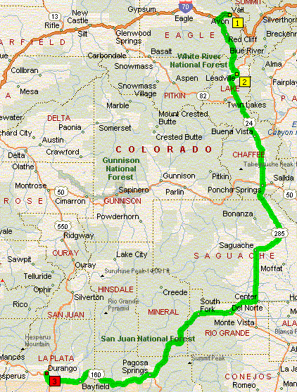
Took 40E through Hot Sulphur to Kremmling. About 8 miles out of Kremmling, I see a man on the side of the road, all dirty and he had his thumb out. Don't know why, but I stopped. Seems he took his 2 wheel truck where only 4 wheelers need to go and he needed a phone and s tow truck. So, on the back he went and off we journed to the only store in Kremmling (this is a 3-4 house small town). He got off and we said our goodbys. He sure was thankful since there are VERY few cars on this road. I continued 40N to 134 and headed East to 131 where I turned south to Wolcott and I70. I wanted back to I70 because someone had told me that I70 from here to Glenwood Springs via Glen Canyon was a must to drive. Boy, they were not wrong!! This is a NARROW canyon shared by the CO River, RR and 4 lanes of traffic. I'll tell you more at the upcoming picnic on during the AK trip. Anyway, at Glenwood I took 82S toward Aspen. Don't go folks - they are developing this whole section and there are lights and slow traffic all the way to Aspen. At Aspen I got the bad news: (1) the pass I needed to Leadville was snowed in and (2) gas was $3.99/gal for prem and (3) it started to snow. Waited for the snow to stop and back tracked to I70. Headed East on 70 to Vail where I got a room. When I got off the bike, I realized that my backpack was missing. It had blown off the bike somewhere on I70 with all my clothes, wallet, cash and more. You would figure with all the info in my wallet and my bussiness cards, someone would call. They didn't nor have they since. After a fun day of riding, not the ending I wished for.

Wednesday
Today is Vail to Durango which ends with 304 miles of fantastic scenery and super roads! I had other routes picked out BEFORE I lost all my money and clothes. So, this was the fastest most direct way back to Durango so I could "re-supply". 6am I'm headed back West on 70 to 24 where I turned S toward Leadville. 24 has been written up in Nalt Geographic and some CO web sites as a must drive. What twist tie roads!! On one curve with a bridge over the river, I stopped to take a picture of the snow covered mountains. I had noticed a lady with a camera but as she approached she asked if she could take a picture of me taking a picture?? I said OK and later she came back with a notebook. Seems she works for a Vail paper that puts out info to tourists of things to do and see. Hopefully she will send me the article so I can share with you. Yes, she was cute. Anyway, back over the Cont Divide to Leadville. I was wondering how come my nose, cheeks, knees and hands were so cold. Leadville's temp said 26!!. I stopped at the Golden Burrow in town for coffee and to warm up. They had a neat t-shirt I had to buy. This town is at 10,200' and their football statium is "2 mile high" stadium. Out of Leadville, you stay on 24S to Buena Vista then you pick up 285S to 112W to 160W. During this route, there is about 40 miles of nothing but 14,000' peaks on your right. I've got the cruise going and really enjoying my tunes when a State PD flags me down. Seems an airplane clocked me at 76. Another "fine day" in black rock. From 160W you go over Wolf Creek Pass (alwasy sometype of construction to hold you up) to Pagosa Springs and into Durango. Bike has run well and so far I'm getting about 44mpg.

Keep after it Santa, We all wish we were there.

oVo

Monday, May 08, 2006

Half Day in the Forest

Sam Houston National Forest is about 163,000 acres of woodlands, farms and privately owned timber. If you ride North of Houston and you don’t see at least part of The Forest, you are simply not trying at all. It includes land in Montgomery, Walker and San Jacinto Counties.

There are several good roads in this area but since this is a half day ride, and since it takes about an hour just to get to the riding area from Pearland (and another hour back) we really only have time to hit one or two of the nice strips up here.

This ride has the added advantage of being very simple to plot. Once in the riding area, there are only a couple of intersections where you will change roads. You won’t need your GPS for this route, just some moderate short term memory.

The first order of business is to get to the riding area North of Pinehurst at the intersection of 1488 & 149. Take any path you choose. I took 288 –> 610W -> 290W -> Bingle -> North Houston Rosslyn Rd -> 249N -> Pinehurst. In Pinehurst, you pick up 149 – one of the primary roads in this loop. Take 149 about 4 miles North to 1488. Then ride ¾ mile west and you are at the intersection that begins the fun part of this ride.

Once you are on 149 north of 1488, just sit back, relax and enjoy the ride for the next 40+ miles until you get to Anderson. You’ll see plenty of other bikes of all varieties. Make me proud and wave at them. You’ll also see lots of tall trees and plenty of curves. These roads are not the peg scraping kind, just gentle twists and turns that are a pleasure to ride.

Once in Anderson, you’ll jog over to FM-1774 and have another nice long segment of about 26 miles to Magnolia. On this stretch, you’ll go past the home of the Texas Renaissance Festival in Plantersville, and a little later you may be lucky like we were and find live music at Henry’s Hideout just North of Magnolia. Be sure to find out their slogan at Henry’s. Then figure out why it’s there slogan.

At Magnolia, pick up 1488 and head back to I-45S and home.

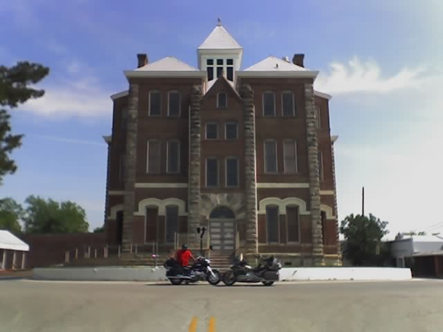
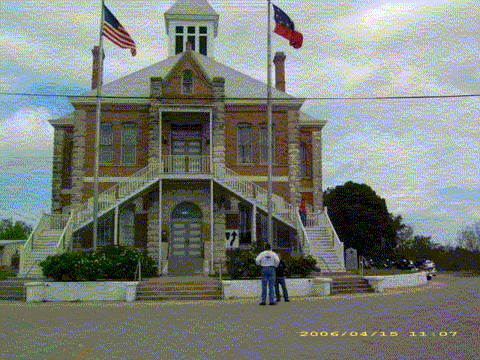
There are plenty of gas stops on this loop so relax and enjoy the scenery like this historic courthouse.


The only negative I consider worthy of comment on this ride is that there is quite a bit of traffic compared to routes further South (like Bellville) or East (like Chuck’s loops.) Still, it’s a great day, and if you stop for a soft drink you are bound to be parked right next to another biker that will chat with you awhile. Enjoy the day and the company.


Turn-by-turn(192 Miles – 4 ½ hours)
Start at FM-518 & SR-288 in Pearland
Ride N 7.5 mi to 610W, Exit and Merge
Continue W and N 12.6 mi to US-290
Ride NW 3.8 mi to Bingle Rd – Turn right
Ride N 2 mi to N. Houston Rosslyn Rd – Bear left
Ride NW 4 mi to SR-249 – Turn left
Ride NW 12 mi to FM-149 – Bear Right
Ride N 3.7 mi to FM-1488 – Turn Left
Jog W 0.7 mi back to FM-149 – Turn Right
Stay on FM-149 about 40 miles to Anderson
At Anderson FM-149 bears left and merges with SR-90S
Ride S 0.2 mi to FM-2819 – Turn Left
Ride E 1.3 mi to FM-1774 – Turn Right
Ride SE 26 mi to 1488 – Turn Left
Ride E 18 mi to I-45S – use ramp and merge
Ride S 35 mi to SR-288 – Merge
Ride S 12.5 mi to 518 where you began


oVo

Saturday, May 06, 2006

Rainy Day Plans

Just because you don't want to ride when there is a 60% chance of heavy weather, doesn't mean you can't feed your motorcycle appetite on a given weekend.

While some of the more adventurous of our riding friends left in the wee hours for a trip to Hodges Gardens, and undoubtably chased the rain East until it finally outpaced them, those of us who either couldn't or wouldn't take a trip in such conditions were left behind to sulk and second guess our decisions.

Not being one to sit and sulk (much) I decided that today was a great opportunity to load up in the cage and see if we could find Brenda some new motorcycle boots. We hit five stores and never bought a boot, but it made for a nice day and here is how you can shop around a bit too if you are so inclined.

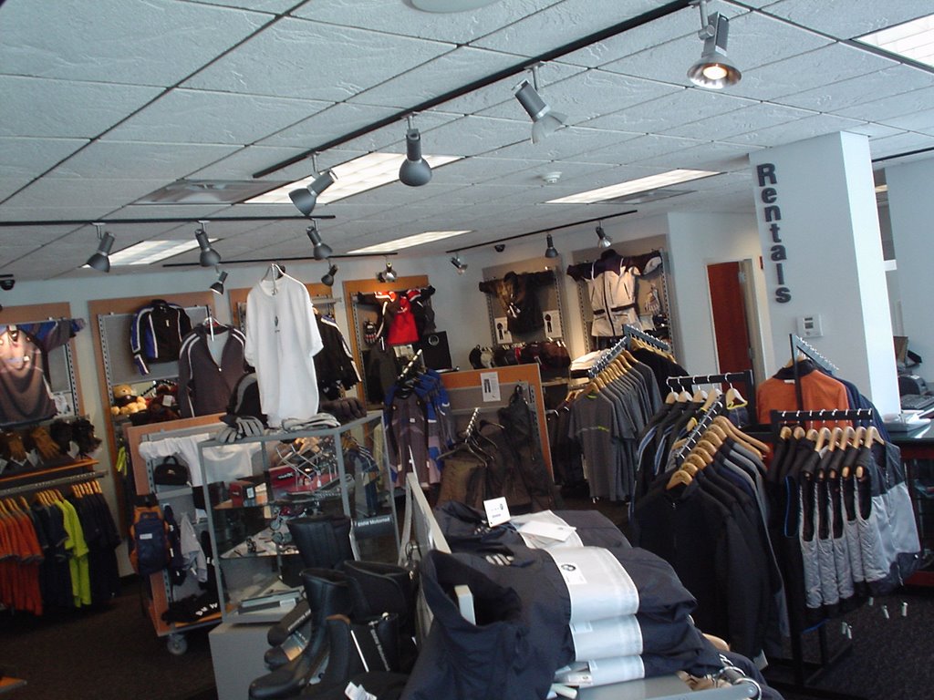
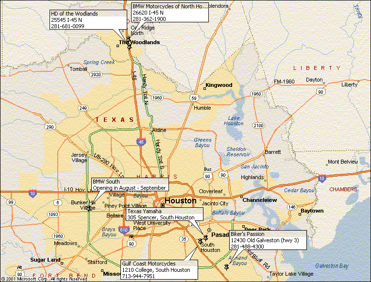
A long trek up I-45 took us to stores that we don't normally get to visit. Our first target was BMW Motorcycles of North Houston. I have a pair of BMW Contour boots that I have used since 2001 and they are the best motorcycle boot I have every worn. Comfortable, light and rugged, these boots suffer through all my abuse and still look decent and perform flawlessly. As a consequence, I wanted Brenda to at least consider what BMW had to offer before buying anything. I'll admit up front that the BMW line doesn't always appeal to the visual senses (they are ugly) but they are so good at everything else, I'm willing to overlook a little quirkiness in the looks department.

BMW Motorcycles of North Houston is one of only two stores in Texas that is allowed to carry a full line of BMW apparel. Lisa, the Apparel Manager does a good job merchandising the store and helping the shopper. I assume that her management is happy with her too, since when I bought a new pair of boots for myself (not for Brenda) she also talked me into trying a $15 pair of BMW socks that promise to keep your foot "Pleasantly cool and dry" by using some sort of "silver ion" in the weave.

BMW of N. Hou will open a second store this summer that will be much closer to most of us. See the map below for the general location or their website for more detail. In summary, I give this store a very high rating for selection and for their customer care.

Next, we wanted to drop in on Harley Davidson of the Woodlands since we usually go to Stubbs and rarely get to see the stores farther away. This is a typical "New Harley" store with all the chrome and glitter that we've come to expect. They had lots of HD stuff and succeeded in selling us a Tee and Jeans for Brenda. I enjoyed a cup of joe while I watched my personal fashion show and we ponied up the $100 or so that we expect to spend when we go to one of those places.

What does HD stands for? Hundred Dollars!
What does BMW stand for? Bring More Wallet!

Making our way back to home turf, we stopped by Gulf Coast Motorcycles to see if their boots were going to work out. Still no luck, but it is always fun poking around those old style stores.

Then we were off to Texas Yamaha in South Houston. This is where we came closest to finding what we wanted. But after some fitting and fussing, the boot just wasn't comfortable enough for the all day type of rides that we find ourselves on.

So off we went to our final stop, Biker's Passion in Pasadena. The Passion didn't have what we were looking for either, but if you haven't gone by some of these independent stores, you really should. They usually sell aftermarket bits and apparel cheaper than you'll find at the OEM stores and the folks inside are generally the owners, not hired help. They are fun to talk to and usually have gathered opinions about the accessory you are thinking of adding and they are happy to share their thoughts with you. Wing Toys, Bikers Passion, Global Motorsports and others have all earned a share of my bike hobby money.

Here is my final piece of advice for today. Ladies, if you have trouble getting your hubby to shop with you, try shopping at bike stores every now and then. I hate the mall, but today was fun.

oVo

Friday, May 05, 2006

Chuck's Durango Loop

Some of you know that our friend Santa-Chuck is on a trip to Colorado, Utah and who knows where else. Do I wish I was with him.? Yup, and you may too when you see what he did today.

Here is Chuck's first day in God's Country:

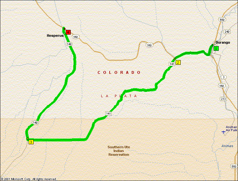
Today was 45 Degrees F when I got up and rode down to Durango for coffee. Messed around some and rode out to Aztec to see a national president for dog rescue. Anyway, if you ever get up this way, I rode a new twistie this afternoon.

From 550 in Durango, take 160 toward Cortez.

About 2 miles down the road, you will see a left turn for "Wildcat Canyon". Once you get on the road, it will tell you you are on CR141.
From 30
to 70mpg you will have a ball.
It terminates into State 140 so take a
right and you will go back to 160. Total fun miles was 19.5.

Tomorrow I'm headed for Grand Junction via Silverton, Uray route.
My brother has a show there Sat night.

Sunday, I want to head to
Wyoming and then start back down the central part of CO. Got to get that picture of WY - heck the guys that went to Vegas got a picture of California!
See ya!
"Santa" Chuck

Thanks for checking in Chuck

oVo

Thursday, May 04, 2006

Kelly's Eats & Sweets Ride

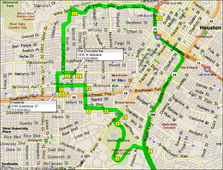
For all you budding route planners out there, here is a challenge for you. Find a route in a heavily urban setting that is interesting, pretty, twisty and results in a full belly and happy palate.

That's exactly what Kelly has come up with on this short ride. It is perfect for a quick evening trip with someone special, or a couple dozen that are not so special but who happen to be around. And he gives it to you just in time for Friday or Saturday Night. Have fun.

Here is how Kelly rides it:

This ride takes you into the city through Herman Park and over to Freebirds for the eats side of the trip, then to the Chocolate Bar for the sweets side, and then throws in a nice set of twisties to top it all off before heading home. The ride can accommodate a large or small group of riders, out for lunch or dinner. Make sure to test all the flavors of ice cream before you decide!

Turn-by-Turn

Start at 288 and 518
288 North 11 miles to N Mac Gregor Way and turn left
N Mac Gregor Way 0.9 miles to Outer belt Dr and turn right

Outer belt Dr 300 feet to Golf Coarse Dr and turn right

Golf Coarse Dr 1.1 miles to San Jacinto and turn right

San Jacinto 0.25 miles to Binz and turn left

Binz which will turn into Bissonnet 0.4 miles to Parkway (Y in the road) and turn right

Parkway 300 feet to
South Blvd. and turn left (one way street stay right)
South Blvd 0.4 miles to Dunlavy and turn right
Dunlavy 0.5 miles to Richmond and turn left

Richmond 0.6 miles to Greenbriar and turn left

Greedbriar 800 feet and turn left into Freebirds parking lot

Freebirds World Burrito

3745 Greenbriar St
Houston, TX 77098
(713) 524-0621


Leaving Freebirds -
Take Greenbriar North (right) 0.5 miles to W Alabama and turn right

W Alabama 0.4 miles to The Chocolate Bar
The Chocolate Bar

1835 W Alabama
Houston, TX 77098
(713) 520-8599


Leaving The Chocolate bar - (note from editor - pump up your suspension a few ticks)
Take W Alabama west (left) 0.3 miles to Shepherd and turn right

Shepherd 1.6 miles to Allen Parkway and turn right

Allen Parkway 2.1 miles to I45 and turn right (South)

I45 South 1.3 miles to 288 and turn right (South)

288 South 13.4 miles to 518


(note the map omits the straight shot portion of the route up 288 from Pearland to the Exit at N Macgregor and the equally straight shot back home)


Thanks Kelly

oVo

Monday, May 01, 2006

Chuck's Ride to Onalaska - Update


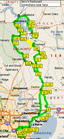
Chuck sent this one in the other day and I think that I'll have to give it a shot soon. It runs up to his favorite part of our region and circles Lake Livingston peaking at the City of Onalsaka, TX. I'm a little suspicious because I can't find the resturant he cites on my map nor on my GPS. And one of the roads is mysteriously missing on my map, but these are all things that will just end up making the trip more fun.

UPDATE: I am happy to report that Jerry's Resturant DOES exist, and it is in Onalaska. Cross the first bridge and start looking for it on your right before you get to the SECOND bridge. Chuck is right, the food is good and the folks are friendly. We got there early, before they started serving lunch. Ron had breakfast, but they accommodated me with a pork chop, mashed taters with white gravy, field peas and fried okra. Ron had to sit and watch as I ate the bread pudding desert. Y'see, breakfast doesn't come with desert (heh, heh, heh!)

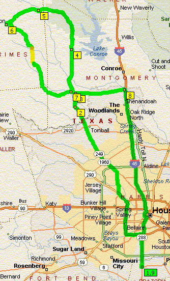
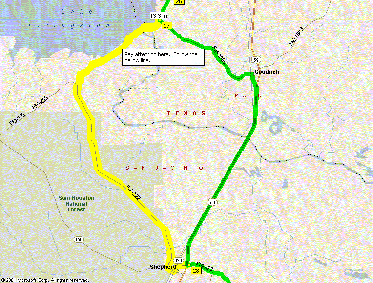
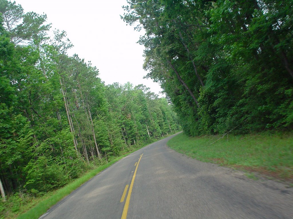
Pay particular attention where you see the yellow routing on the map below (and blown up to the Right) That's where the road is missing on my map. FOLLOW THE YELLOW until it joins back up with the green in Shepherd. The Yellow matches the the turn-by-turn directions below. You'll be ok if you miss that turn, but you may miss a couple of nice views of the lake too. The GPS says all is well - "trust me."

UPDATE: I can also confirm that the yellow road DOES exist and it DOES go all the way through as shown here. Ignore your map, it really is there.
I guess the only other comment we can offer is that 523S is a really nice twisty road. Lots of fun. There are other fun spots on this trip too, so you should try it out.

Even if all you do is remember
how tall pine trees grow, it'll be worth your while.

Here is Santa-Chucks trip to Onalaska:

Meet at Diner IH45@ Dixie Farm Rd (1959)
E on 1959 to Hwy 3 (go left)
3N to Genoa Red Bluff. Go right
Genoa Red Bluff to Red Bluff. Go left
Red Bluff to Fairmount Prky. Go right
Fairmount to 146. Go left
146N to 565. Go right
565 NE over IH10 to 1409. Go right
1409N to Dayton. Cross over 90, over RR and 1st street, turn right onto 1008.
1008N to 321 Go right
321N to 105. Turn left
105E to Cleveland. Turn right on business 59.
59B to 2025. Turn left
2025NW to 945. Turn left
945NW through Evergreen then stay on 945 N and E to 156. Turn right
156E just a short distance to 224. Turn left at light. This is a neat twisty road so watch your speed.
224N to 156. Turn right.
156N to 190 at Point Blank. Turn right.
Take 190N to Onalaska. Before the (second) bridge over Lake Livingston you will find Jerry’s Rest on your right. Good food at great prices.

From Jerry’s Rest, take 190E to 3126. Go right
3126S around lake to 1988. Go right
1988S to 3278. Bear right
3278SW to 222. Go right
222S to Shepherd. Go left on 59B briefly to 223. Go right
223S to 787. Go right
787SW to 2518. Go left
2518S over 105. Stay on this road. It becomes 163 and then CR2316. It terminates at 1008. Go left.
1008S through Kenefick to Dayton

At this point, rider can elect to save time and take 90 or 146 home. Long way is reverse course from route that morning.

The ride is about 6/7 hrs with gas stop at Cleveland and Onalaska for gas and rest. Mileage is 302 miles on long route home.

Enjoy the smells of and the lake effect (temperature). Good views and good roads with something for everyone.

“Santa” Chuck

Chuck is heading to Colorado and Utah this week. He promises some routes
for those of us who want a slightly extended trip when he gets back . Stay tuned.

If all this route reading is making it even harder to tend to the necessities instead of riding every day, check MidLifeCycles.com 'cause we've got our big trip to Arkansas coming up soon. You don't want to miss those twisties.

oVo

Friday, April 28, 2006

Chuck's Circumnavigation


Santa-Chuck and his crew of elves went all out on this ride just three or four weeks ago. This route is 330 miles and could take you 10 hours without including meal and gas stops. Now, that's according to my mapping software, your times will vary - usually shorter. Santa and his elves ran it including meals and gas in 7 1/2 hours.

Anyway, load up and take this ride when you want to see just what all the hubbub is about in the territory NorthEast, North, NorthWest, West and South of Houston.

Here's how Chuck saw it:

We met at Dixie Diner, IH45 @ Dixie Farm Rd(1959). Left diner at 9am
Leave the Diner through the parking lot back to 1959 and turn left to SR 3

Take 3 to Genoa Redbluff, turn Right to RedBluff

Take Redbluff to 146 and Turn Left to Mont Belviu

Continue on 146N through Mt Belview to 1942. Go left

Be careful
on the RR tracks crossing 1942. They are very rough–slow down
Continiue on 1942N to Barrett.
1942 merges with 2100. Follow 2100 left

2100 N through Huffm
an. North of Huffman, 2100 becomes 1485
1485 W through New Caney, past IH59 to 242. Go left

242W past IH45 to 1488. Go left

1488W to Magnolia. At 1774 go right

1774N through Plantersville to Anderson. Stop in Anderson to top off gas.

See historic old court house and memorial to Confederates

90 N out of Anderson to 244. Go left

244NW through Carlos. Stay on 244 over 30 about ¼ mile to Yankee
Tavern on your right. Great food, cold drinks and biker friendly. LUNCH We got here at 12:30pm

Starting back - 244SE to 3090. Go right.
Have you ridden the 3 sisters? 3090 is sister #4 with 20 miles of twisty roads and great views.

3090S to Hwy 6 (outside Navasota. Go right

6S to 90/105. Go right

105SW (Tx Independence Trail) to 390. Go right

390N and W through Independence to (intersection of 290). Gas up and rest.
Go right on 2
90.
290W just a short distance to 2502. (stay in left lane on 290). Go left
2502SE to Nelsonville. At 159 go left
159E to Hwy 36. Go right

36 SE through Bellville to 529. Go left

529E to 359. Go right

359S through Brookshire, over IH10 to Flulshear (1093). Go left

1093E to
359. Go right
359S to Hwy 90A. Go right

90A a short distance to 762. Go right

762S to 1462. Go left
1462E to CR42. Go left.
This is a narrow 2 lane 1 bike road. Spread out and enjoy the scenery but watch out for wildlife.

CR42 E to 521. Go right

521S back to 1462 (about 2 miles). Go left

1462E into Alvin
We stopped the trip here.
Take your own route home from
370 miles from Dixie Diner to Alvin. Time was 7.5 hrs. Enjoy the ride “Santa” Chuck

Thanks for another great looking route Chuck

oVo

Wednesday, April 26, 2006

Jim, Jim, Jim and Roger's wild ride (to Vegas)

Some of our friends have a different idea about the makings of a relaxing ride. Here is how one of the Jim's saw their recent trip to sin city:

We met at 5:00 am Friday The 14th in the Lowe's parking lot by Gulfgate. Off we went into the fog, taking the 610 loop around to 290 towards Austin, where we then went north on US 183 to TX 29. Stayed on TX 29 through Llano (it was still too early for lunch at Cooper's). Then took TX 71 to Brady, US 87 to San Angelo, through Big Spring and Lamesa. In Lamesa, we picked up TX 137 to Brownfield, then US 380 into New Mexico. Stayed on US 380 until we got to Roswell, New Mexico, where we spent the night after riding about 725 miles.

The aliens are very friendly there, so feel free to check into the Ramada Inn on the west side of town. Saturday morning we left Roswell and headed out on US 380 towards Socorro, where we had lunch. Then we took US 60 into Arizona, and at Show Low, took AZ 77 towards Holbrook, where we headed west on I-40. Made it to Flagstaff, where we spent a COLD night. Sunday morning (with the temp at 31 degrees) we headed further west on I-40, where we exited at #139 and got on Historic Route 66, re-joining I-40 at Kingman. Then it was west on AZ 68, crossing into Nevada where it turns into NV 163.


When we got to US 95, we turned left and rode about 1 mile to make a ceremonial visit to California. Then it was back up north on US 95 to our destination. We arrived at "Sam's Town Hotel and Gambling Hall" early in the afternoon. After freshening up a bit, we rode to the airport to greet our wives, who had just arrived on a Southwest airlines flight. Seems it only too them 3 hours to get there instead of 3 days. But they missed out on things like dodging (and sometimes hitting) prarie dogs, seeing various wildlife along the way, getting a case of "monkey butt", wondering what would happen if you broke down in the middle of the desert where the nearest mechanic was 300 miles away, or having that full, bloated feeling, and knowing the nearest bathroom was at least an hour away. They also missed some of the most incredible scenery anywhere, that can only be enjoyed from the seat of a motorcycle. You could never get the same things out of a trip like this in a car. I know, because now I've done it both ways.

Thanks for the trip info guys. Glad to have you back.

oVo

Tuesday, April 25, 2006

Chuck's Ride to Big Thicket

Not every riding group has their own Santa, but Midlife Cycles not only has one, they have THE one. And in the off season, Santa runs the back roads of Texas, Colorado, Utah and who knows where else under the alias of Chuck.


Last week, Santa-Chuck went on a loop to Big Thicket National Park

Here is the ride the way Chuck experienced it:

I left Dixie Diner and rode the back roads about 1 hr to Mt. Belvieu, then N to Rayburn, Romayor, Ace then E to Segno and started back S via Saratoga and E to Batson. I stopped for gas here at 160.4 miles. Some basketball 3-4 graders had buckets at the intersection 770/105, I needed a stretch, so I walked over. Their coach was there - it seems they made the national basketball playoffs and were collecting money. I gave them a $20 and told the kids and adults about our ride next Sunday (Ride for Kids). They may stop by. Neat bunch of kids - I had to spend more time telling them about MidLife Cycles since they saw the emblem on the back.

I got to Anahuac at 12:30 and had some of the best CFS, home made
mashed and a super fresh salad bar. Finished with a wonderbar homemade peach cobbler with blue bell. $10 w/o tip. It is called Woods Catering and it is just West on 61 at the intersection of 563. Headed home and arrived at 2:30pm.

The total trip from Dixie Diner was 242 miles
and driving time was 5 hrs. The fresh, cool, sweet smelling air was to die for. This is not the part of Tx where you see blue bonnetts and Indian paintbrush but lots of other flowers and greenery was everywhere from the recent rains. I'm still amazed to see houses with blue tarps from Rita and many with no one living there. Hope you had a wonderful ride today (if you went) and if not, shame on ya! "Santa" Chuck

Turn-by-Turn
Exit Dixie Diner (IH45/FM1959) and go 1959E to Hwy 3. Turn Left
Hwy 3N to light at Genoa-Red Bluff. Turn right
E on Genoa-Red Bluff to Red Bluff Rd. Turn left
NW on Red Bluff Rd to Fairmont Prkwy. Turn right
E on Fairmont to Hwy 146. Turn left
N or 146 to Business 146 - bear right
E on B146 to 55. Turn right
55 dead ends into 2354. Turn right
2354N to 3180 (bear right)
3180 over IH10 to 565. Turn right.
565E to 1408. Turn left
1409N into Dayton. At light, go over Hwy 90, over RR tracks to stop sign. At first street after RR tracks, turn right (1008). Fill gas in Dayton if small tank
1008N to 321. Turn right
321N to 163. Turn right
163E to 2518. Turn left
2518 (over 105) to 787. Turn right
787NE to 2610. Turn left
2610N to 146. Turn left
146N to 943. Turn right
943E to 2798. Turn right
2798S to 787. Turn left
787SE to to 770. Turn right
770W to Batson. Fill gas tank (160 miles from Dixie Diner)
At Batson, 770 heads south.
770S to Shiloh. Turn left on 563
563S to Anahuac.
At 4 corners in Anahuac, turn right off 563 to 61. Follow 61W (.2 miles) to Woods Catering on left. Good quality food at excellent prices. Homemade peach/apple cobbler.

Going home, take long or short route depending on time. I took short route.
Back to 563N to IH10.
IH10W to 565. Exit, go under IH10 SW on 565
565SW to 146. Turn left
146S to your exit.

Thanks for the route Chuck.

oVo

Monday, April 24, 2006

South Main Baptist Church - Saturday, April 29

South Main Baptist Church in Pasadena is hosting their first ever motorcycle ride. They'll leave the church property at 7:30AM Saturday morning after having some cofee and donuts at 7.

The ride will take them up the great route to Bellville where they will stop at Newman's Bakery for lunches and lots of sweet stuff. They'll be back home in time for supper, having run some of the sweetest twisties South of 290.

The map and turn by turn directions are below.

Whether you go on the ride or not, be sure to swing by the church some Sunday and see if this is the church for your family.

oVo


Instruction
Depart Church parking lot
Turn LEFT (South) onto E Beltway 8 [E Belt Dr]
Merge onto SR-288 [South Fwy] (South)
At SR-288 CR-56 Exit, turn off onto Ramp
Turn LEFT (South) onto FM-521
Turn Right (West) onto CR-42
Turn RIGHT (West) onto (W) FM-1462
Turn Right on FM-762
Bear Right on FM-2759
Continue Straight on SR-99 [Grand Pkwy]
Turn LEFT (West) onto US-90 Alt
Turn RIGHT (North) onto FM-359 [Skinner Ln]
Turn Left on Winner Foster Rd
Turn RIGHT (North) onto Bois D Arc Ln
Turn LEFT (West) onto FM-359 [FM-1093]
Bear RIGHT (North-West) onto FM-1489 [Simonton Rd]
Cross I-10 on the overpass
Turn RIGHT (East) onto US-90 Bus
Turn LEFT (North) onto FM-359 [Bains St]
Bear left West) on FM-1458
Turn RIGHT (West) onto FM-3318
At FM-3318, Sealy, TX 77474, stay on FM-3318 (West)
Turn RIGHT (North) onto Diemer Rd
Turn RIGHT (East) onto Mt. Zion RD
Turn LEFT (North) onto Sunny Side Rd
Turn LEFT (West) onto FM-529 [Crump Ferry Rd]
Stop for Lunch at Newman's Bakery
Leave Newman’s on SR-36 continuing West [E Main St]
Turn LEFT (South) onto S Masonic St
Turn RIGHT (West) onto W Austin St
Turn LEFT (South-West) onto Mill Creek Rd
Bear RIGHT (South) onto FM-949
Turn LEFT (East) onto FM-1094
Continue (South-East) on Columbus Rd
Continue (East) on FM-1094 [Columbus Rd]
Turn RIGHT (South) onto SR-36 [N Meyer St]
Turn RIGHT (South-West) onto SR-350 Spur [N Circle Dr]
Bear LEFT (East) onto US-90 [HWY-90 W]
Turn Right (South) on FM-1458
Bear RIGHT (South) onto FM-1458 Rd S
Bear LEFT (East) onto FM-1458
At FM-1458, stay on FM-1458 (South)
Turn Right (South) on FM-1093 Rd E
Bear LEFT (South-East) onto N 1st St
Turn LEFT (East) onto SR-36
Bear LEFT (South-East) onto US-90 Alt [SR-36]
Turn RIGHT (South) onto SR-36 [1st St]
Turn LEFT (East) onto Southwest Fwy [US-59]
Turn LEFT (South-East) onto FM-762 [Thompson Rd]
At near Booth, stay on FM-762 [FM-1994] (South)
Continue (South) on Beard Rd [FM-762 Rd]
Turn LEFT (South-East) onto (W) FM-1462
Turn LEFT (North) onto CR-42
Turn RIGHT (South) onto FM-521
Turn RIGHT (East) onto CR-56
Merge onto SR-288 (North)
Bear RIGHT (East) onto Beltway 8 [S Sam Houston Pkwy E]
Arrive Back at Church

oVo

Thursday, April 20, 2006

Goldwing LCD


Isn't that a nice view from the cockpit of the 2006 Goldwing. OK, I admit it, this is a pic of a 2001 wing. Can you spot the differences? (There are at least three that you can see from this pic. If you all participate and email me your guesses, I'll publish the correct answers next week)

I couldn't get a nice pic of Brenda's cockpit what with flash, focus and overall photographic incompetence on my part, so I pulled this pic off the web. The point remains the same and that is that it is startling to me how dependent you can get on instrumentation, and how quickly.

The LCD screen went out on Brenda's wing last week. Three quarters of the screen was a sort of streaky black and you could see the display trying in vain to change as the situation demanded. The other quater was clear and unchanging. In all, the LCD screen that is home to the odometer, trip meters, time of day, audio status and settings, CB information, and on some wings the GPS was totally useless. I felt like I was flying blind. And on a month old wing with only about 2000 miles on it. My Harley never had this problem. 'Course it never had an LCD screen, CB or Stereo either, not even a clock. It does have two trip meters though, does that count?

After some schmoozing at Pasadena Honda, Mark the service manager ordered a new LCD screen for me last Thursday. Don't even ask how I got him to do that without even bringing the bike in for a look-see. Maybe I just have an honest face. Ok ok, I honestly have a face, is that good enough?

Well Mark's faith in me paid off. While I waited today, they replaced the $700+ component and now all is well again. No word on what caused the failure, but apparently they've had this problem in some previous GL models.

This one went all the way to Honda engineering though because it is the first failure of this type on a 2006 GL. Can you tell that I am basking in reflected glory? I am also hoping that the rest of you '06 owners don't have this problem, but if you do, rest assured that Mark has seen it before, and if he takes care of you like he did me, you'll be one satisfied customer.

oVo

Tuesday, April 18, 2006

Kelly's 4 Hour Route - UPDATE From Kelly


NOTE: If you've already read this post and just want to see what Kelly had to say after he ran the route, head down to the Turn-By-Turn section and back up one paragraph.


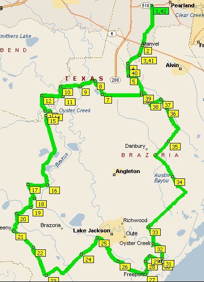
Leave it to Kelly to find back roads, twists and turns where we mere mortals simply hit the highway. This route bodes well for those of us lucky enough to be able to go on the Midlife Cycles annual trek to Arkansas. If Kelly can find these roads in the coastal plain, just think what he can do in the mountains.

If you leave Pearland at about 10 - 10:30, you'll be through the obligatory trip down CR 42 and the new obligatory section down Cow Creek Rd in time to find lunch at Cowgirls Kitchen in West Columbia. You'll be going slow enough to spot it on your left, thanks to some construction going on. Just order whatever is on special. Today it was chicken fried steak and it was great. Mashed potatos covered in white gravy, green beans, corn and of course the steak. Lauren is likely to ask you if you want two steaks or just one. "It's the same price" she'll say. If you leave here hungry, it's your own fault.
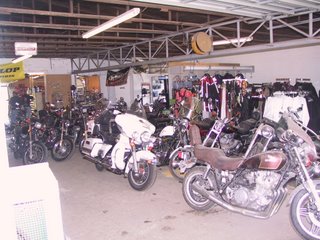

After lunch, and before you get back up to speed, take a look on the right, where you'll see First Capitol V-Twin. If you want to remember what Harley shops used to look like before yuppies discovered the mark, stop in here and poke around for a minute. All the bikes are used 'cause this isn't a bonafide HD shop. And thanks to the construction and the apparent priorities of this shop, they are also all covered in dust. Peak in the back and you are likely to see a Vespa motor scooter up on the rack getting a once over. Don't miss the old choppers leaking oil on the floor either. Take a hard look here, you may find a bargain.

Once you've gotten your fill of a real bike shop, get back to the twisties that lead you to Sweeny and around the horn to Lake Jackson. You've not only traveled 90 miles at this point, you've also been down to about 5 ft above sea level and are soon to be even lower.

At Freeport, it is obvious that you are in the coastal plain and you can look left and right as far as the eye can see. (Hmmmmm, when is it that you can't look as far as the eye can see?) What I mean to say, is that you'll enjoy riding on top of Levee Rd and seeing all the marsh sights that you may not get to see very often.
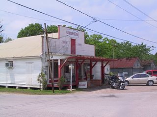
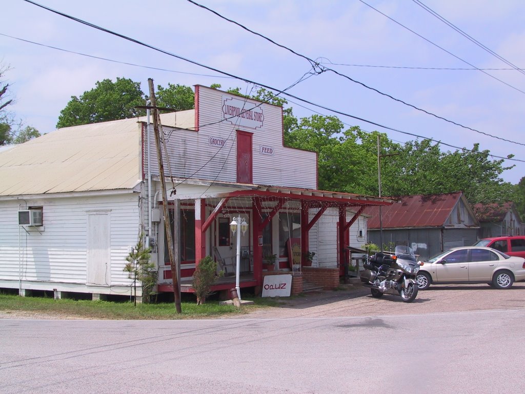
You are basically headed North and home now and there will be some straight sections here. You'll get to Liverpool about an hour and a half after lunch so you might want to stop in for a Big Red at the General Store. If you want to stop anywhere else in Liverpool, you'd better know one of the 2,574 people who live there cause I didn't see anything else in that town. Nice folks though. Some of our group have met the local constabulary and have suggested that you might want to keep the speed needle in a conservative range around here. Rather than meeting the local sheriff, I suggest you ask to see the new kittens out back.
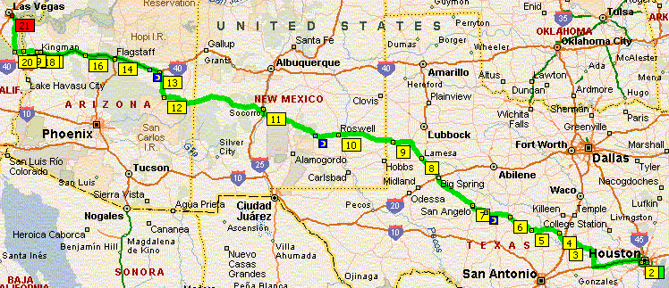
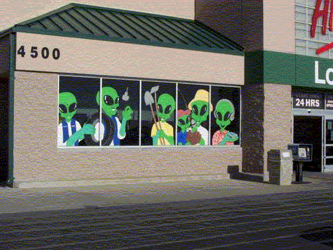
The rest of your trip covers some of the same roads that got you down South. In case you missed it on the way down, be sure to look left and spot the private ski lakes that someone built along Brister Rd. Man these folks must like to ski. Do you think it has something to do with the lean? Maybe they would also like riding bikes.

Enjoy this ride and be sure to thank Kelly for the turn-by-turn directions next time you see him.

Do you have a route that others might enjoy? Email me and let's get it posted.

Kelly ran this route Saturday and had this to say;

Ran the route just as posted, well maybe with a little extra purpose. Keep in mind the more bikes you have on a ride the more time it takes. This is what the GPS said when I finished.

Total time 3 hrs 13 minutes
Driving time 2 hrs 59 minutes
Stopped time 14 minutes
Average speed 52.6 miles per hour
Total miles 157.2

Riding with a little less purpose (lets say one that keeps everyone happy) and several short stops you can do this ride in four hours. If you have several bikes going at an easy pace and stopping for some sights plan on five hours. If you stop to eat make it five to six. This route is mainly back roads, so if you want to eat you may need to wander off the path a bit. As you ride the loop if you find a good place to eat let us know so we can post it.

This route crosses main roads many times, if you need to cut it short you can very easily.

Thanks Kelly

Turn-by-turn
Start Pearland 518 (Broadway) and 1128
Go south on 1128 for 7 miles to Hwy 6
Cross hwy 6 onto Master rd. which will turn into Manvel Sandy Point rd. and go 6 miles to Brister rd.
Turn left on Brister rd. and go 4.25 miles to 1462
Turn right on 1462 and go 6.3 miles to 521
Turn right on 521 and go 2.5 miles to 42
Turn left on 42 and go 7.7 miles to 1462
Turn right on 1462 and go 3.4 miles to Cow Creek rd.
Turn left on Cow Creek rd which will turn into Nash rd. and go 2.8 miles to Pecan rd.
Turn left on Pecan and go .9 miles to Forest dr.
Turn right on Forest and go .3 miles to Brazoria River rd.
Turn right on Brazoria River rd. and go 1 mile to Nash rd.
Turn left on Nash rd. and go 12.3 miles to 35
Turn right on 35 and go 3.1 miles to 36
Turn left on 36 and go 1.9 miles to 522
Turn right on 522 and go 4.9 miles to 1459
Turn left on 1459 and go 3.2 miles to 524
Turn left on 524 and go 4.4 miles to 521
Cross 521 onto 316 (Stratton) and go 5 miles to 2611
Turn left on 2611 and go 7.7 miles to 36
Cross 36 onto 2004 and go 3.7 miles to Brazos River rd.
Turn right on Brazos River rd. and go 5.5 miles to 36
Turn left on 36 and go 5.1 miles to 1495
Turn left on 1495 and go 2.2 miles to 523
Turn right on 523 and go 1.2 miles to 332
Turn right on 332 and go 1.9 miles to levee rd.
Turn left on Levee rd. and go 3.8 miles to 523
Turn right on 523 and go 3 miles to Hoskins Mound rd.
Turn right on Hoskins Mound rd. and go 12 miles to 2004
Cross 2004 onto Liverpool Hoskins rd. and go 11.8 miles to 35
Cross 35 and go 1.7 miles to Parker School rd.
Turn left on Parker School rd. and go 2 miles to Russell rd.
Turn right on Russell and go 2.2 miles to 1462
Cross 1462 and go .5 miles to Brister rd.
Turn right on Brister and go 4 miles to Manvel Sandy Point rd.
Turn right on Manvel Sandy Point rd. and go 6 miles to Hwy 6
Cross Hwy 6 and go 7 miles to 518